

LONE STAR WAY UP - AN ADVENTURE THROUGH TEXAS' PARKS
Words by Brandon Weaver - Photos by Jerod Foster
The dark and misty night had engulfed us on the lonely west Texas highway, and I was riding with a smoked shield. It’s a bit of vanity that’s carried over from my old days of sport bike riding. I hate the look of clear shield. Friend, riding partner, and photographer Jerod Foster was in front of me as we motored down State Highway 54 en route to Guadalupe Mountains National Park. Jerod and I talked over our helmet radios, “You see that Highway Patrol back there?” I asked. The Texas Department of Public Safety trooper was parked against a barbed wire fence off the shoulder of the road. The black and white Chevy Tahoe was nearly invisible. “Yeah, I saw him,” Jerod’s voice crackled over the radio. We were a solid 5 mph under the speed limit. Fall had descended upon the Texas high country and it was too cold to go any faster. We were on an epic journey across the state, and it was our last day on the bikes.
The trooper watched us ride by and took note: two Africa Twins, one rider in Revit gear the other wearing Klim (I’m embellishing the trooper’s insight here, but maybe he’s a moto guy). A few minutes later, the next machine past his windshield was a 2002 gold Nissan Xterra followed by a 2000 white Chevy pickup. No one in the convoy was speeding, but the trooper’s interest was piqued. He tucked in behind the Chevy, ran the plates, and discovered the registration was out of date. He then passed the pickup and pulled up behind the dust covered Xterra. A stack of bags packed with camera equipment obscured the SUV’s back window. The trooper flicked his lights on and pulled over our video crew, director Madison Walker and her intern Adam Bennett. The Chevy truck kept driving.
Yes, that title was inspired by the “Long Ways” documentaries from Ewan McGregor and Charley Boorman; and just like Ewan and Charlie, we had a video crew. They were shooting a short doc for the Texas Parks and Wildlife PBS Channel. We didn’t circumnavigate the globe. We crossed Texas and camped at state parks along the way. The journey took us 1,400-miles (mas y menos) from the state’s lowest elevation along the coast to the base of its highest mountain, the 8,751 ft Guadalupe Peak.
SEA RIM STATE PARK TO HUNTSVILLE STATE PARK
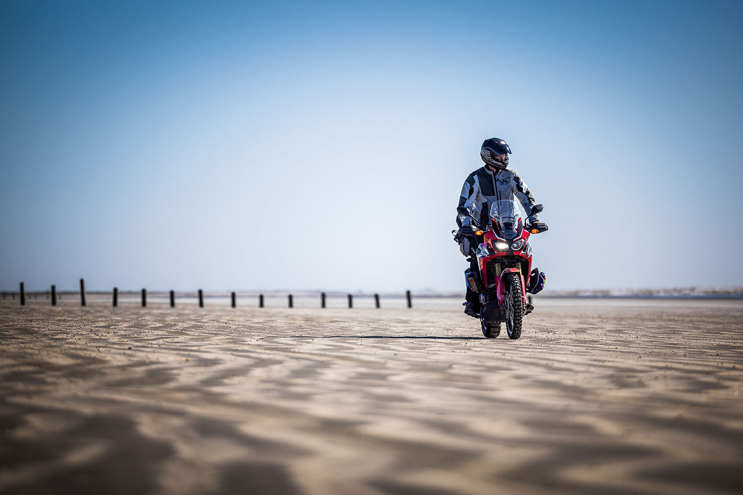
Our journey started at Sea Rim State Park in the southeast corner of the state. We pitched our tents along a grassy bank next to a marsh that separated us from the beach. There are alligators in the freshwater marsh, but park staff assured me there’d never been an incident. Still, I gave myself a buffer from the water, and that buffer was named Jerod Foster. He’s the Ewan to my Charlie. An alligator would never eat him. He’s charming, affable, and –darn it – folks really like him. I just like to pop wheelies. We are a photographer-writer team, on assignment for Texas Parks and Wildlife Magazine. The majority of our gigs together have been about bike-packing, the pedal-powered cousin to adventure motorcycle touring. This petrol-powered trip was a dream realized. I grew up in the 80s reading the classics: Motocross Action, Dirt Bike, and Dirt Rider. I wanted to be on the MXA wrecking crew, railing a bermshot in those magnificent four-color glossy pages. I didn’t have the riding chops, but it’s what inspired me to be a writer.
That first morning, Jerod shot me riding along the rippled sand of a beach left unblemished from the overnight tide. You can’t tell, because of that smoked shield, but I’m grinning ear to ear. We left the beach and headed inland. As we rode along the coastal plains, we were pummeled by 26-mph sustained winds with gusts in the 40s. The tall strands of sugarcane plumegrass and eastern gamagrass whipped violently along the roadside ditches. We stopped for lunch and a windbreak at the Pho Xpress in Winnie, Texas. The calm of the restaurant also gave us the opportunity to set up our helmet radios. Jerod deciphers the PACKTALK’s syncing procedure. We put our helmets on in the restaurant. “Can you hear me?” he asked from across the table. “Copy,” I gave him the thumbs up.
The coastal grasses faded and we entered the towering loblolly and longleaf pines of east Texas. The evergreen giants appeared intermittently like lone sentinels on the front. Once we penetrated the Sam Houston National Forest, the timber proliferated and we were entrenched in trees. The wind subsided and the smell of pine permeated the air. After 100 miles of pavement, we were finally on dirt.
The goal of this trip was to connect our state park campsites with as many county gravel roads as we could. In the end, only about 10-percent of the whole route is unpaved and most of that lies in west Texas around Big Bend National Park and Big Bend Ranch State Park.
Nestled amongst the pines, Huntsville State Park was our campsite for the night. We rode in after dark and struggled to find our campsite in the pitch-black blanket of conifers. It was a blissful night under those majestic trees.
HUNTSVILLE STATE PARK TO HILL COUNTRY STATE NATURAL AREA
We had brief stretches of gravel between long sections of pavement. The Pineywoods transitioned to the less claustrophobic Post Oak Savannah, rolling grasslands punctuated by pocket forests of oak. It’s the kind of land that beckons for a little low-slung prairie home with a big porch and a shop full of motorcycles. We briefly touched the Blackland Prairies (dark rich soil that yearns to be made a motocross track) before entering the Texas Hill Country. It was all business as we crossed the urban sprawl of the I-35 corridor.
Our bed down destination was the Hill Country State Natural Area. It’s less developed than a state park so things feel a bit rustic, like camping on a friend’s ranch. Due to proximity near Austin and San Antonio, campsites are always booked. Luckily, we snagged the last spot, an equine campsite. Per our modus operandi, it was dark when we arrived. The next morning was like opening a topographical present. A sea of tall grass sat motionless on the windless morning as green covered mesas and buttes rolled across the horizon.

HILL COUNTRY STATE NATURAL AREA TO DEVILS RIVER STATE NATURAL AREA
We stopped for lunch at the Lost Maples Café in Utopia. A woman stood on the front porch ribbing some of the locals. She eyed us as we approached. “You can sit on the porch,” she pointed to an open box. “But you gotta take a kitten,” she cackled. Tempting, but kittens are never free. We sat down and she continued to hold court: “You don’t have to get dressed up to go church anymore.” – “Pie fixes everything.” – “I’m glad you guys are filming our parks.” And then she disappeared.
We left Utopia, picked up a gravel road out of town, and caught the last half of the most popular paved ride in Texas, The Twisted Sisters Loop: baggers, sport bikes, scramblers, and convertibles – oh my.
I’ve never embraced the helmet radio. Jerod had researched different models and recommended we use them on this trip. A helmet has always been my safe place, and I wasn’t sure I needed an external voice in there. I’ve never been more wrong. We had fantastic conversations as we motored across Texas. Did I mention he was affable and smart? “That rock outcropping is the telltale sign we’re getting close to the Trans Pecos,” Jerod said as we rode. The Trans Pecos is the desert mountain region of west Texas. It’s big country that gets bigger as you head west.
Dolan Creek Road is 18-miles of dusty caliche (gravel) riddled with washboards. In an SUV it’ll rattle the plastic pieces of your dash to a perpetual creak. On an Adventure bike, it is glorious. Madison, our video director, launched a drone for a hero shot of us riding through the rolling desert scape. It is the entrance and exit (out and back) to Devils River State Natural Area campsite for the night. We arrived at dusk and basked in the last rays of sunshine bouncing off the canyon wall.

DEVILS RIVER STATE NATURAL AREA TO BLACK GAP WILDLIFE MANAGEMENT AREA
We rode south toward Del Rio and then followed the border northwest into the mountains of west Texas. Jerod and I have adventured extensively in this region. Folks always ask if it’s safe. We’ve never encountered a dangerous or threatening situation. With each mile gained, those mountains expanded and instilled purpose on the horizon. Their purple silhouettes danced with a golden sunset under a blanket of blue ethereal light. It was all capped with dark cumulus and white wispy cirrus clouds. Jerod narrated the roll call of mountains into my helmet: The Maderas Del Carmens, Casa Grande, El Jardin, the Chisos…
Once the dance was over, the sky turned black and we headed south on FM 2627 toward Mexico and into an abyss. We were camping in the Black Gap Wildlife Management Area where the state has successfully reintroduced Bighorn Sheep back into their natural habitat. This area is the least visited section of the Big Bend Region. It’s far off the beaten path, lacks amenities and there’s no real signage for trails or campsites. It would do just fine. We registered inside a dimly lit shed next to a maintenance barn. There were no frills here. We secured a campsite down a dark, remote double track road with shifty rocks bordered by all manner of flora that aims to stick you. Don’t worry, I had that smoked shield flipped up. The headlights are good on the Africa Twin but not that good.
BLACK GAP WILDLIFE MANAGEMENT AREA TO BIG BEND RANCH STATE PARK
This was the day of big gravel. The plan was to circumnavigate Big Bend National park along its backcountry roads: Old Ore Road to River Road to Old Maverick Road. 111-miles of sandy, rocky, remote desert backcountry nirvana. The previous 975-miles were basically one long ride to this trailhead. I rode to the Permission Gap pay station. On the side of the kiosk there was a list of backcountry road closures due to recent rains. River Road East and Old Ore Road were on that list. Strike one! I handed my entrance fee to the nice person dressed in NPS green and khaki. I grabbed my handlebars and the steering felt slow. I knew it instantly. My front tire was flat. Strike two! We pulled into the parking lot and swapped out the tube. It took a bit of time. I attempted to air it up with several devices and then discovered I’d pinched the tube. Strike three! I was careful with our last tube (we had patches). It held air but our day was done, and we were out of time. Big Bend NP is a big place and it takes all day to drive the tarmac, which is what we did. We picked up the south end of Old Maverick Road, traversed some gravel and exited the west end of the park.
We stopped for dinner in Terlingua and headed to our campsite in Big Bend Ranch State Park along FM 170. The road undulated in and out of pockets of cold air. Hints of moisture wafted under my helmet. The Rio Grande River was right there and I was no longer thinking about lost opportunities. I was thinking about the here and now. We were in the rhythm of the trip and nothing else mattered.

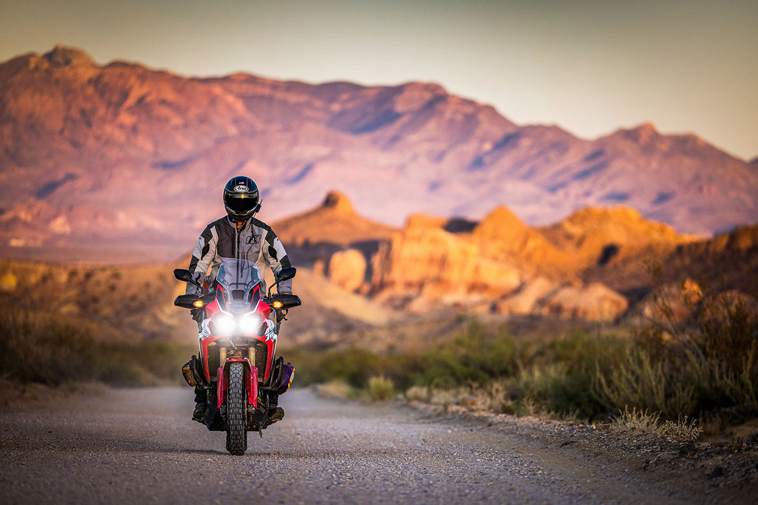
BIG BEND RANCH STATE PARK TO GUADALUPE MOUNTAINS NATIONAL PARK
We rode Big Bend’s other River Road, the paved FM 170 that parallels the Rio Grande River to the border town of Presidio where we stopped at my favorite Mexican food place in Texas, El Patio Cafe. The green beef enchiladas are the best. We skirted the border a few more miles to Ruidoso and hit Pinto Canyon Road, the best gravel in the state. As we rode through the Chinati Mountains, we encountered a roaming border patrol unit. They were friendly and stopped to chat with us about bikes. We stopped in Marfa and had dinner at Para LLevar, a little market with craft brews and Neapolitan pizzas. We lingered a bit too long in their expansive courtyard.
By the time we got to Van Horn it was dark, and trouble loomed ahead. This is that segment of highway where our story began. Madison, our video director, was pulled over by an inquisitive Texas Department of Safety Trooper. Jerod and I had no idea. We arrived at the Pine Springs Campground and waited, wondering what the hold up was. The white Chevy pickup pulled up. It was TJ Martinez, the third camera on our crew. “Where’s Madi,” I asked. “That trooper pulled her over,” he said. “Were y’all speeding,” I asked. “Nope,” TJ replied.
Finally, Madison pulled into camp. She was visibly unnerved. Apparently, our convoy fit the profile for human trafficking. He pulled her over because her rear glass was obscured and her SUV was the type human traffickers used. We all shook our heads. It was late, cold and the mist was getting heavy. It was time to crawl into a tent. We had a mountain to climb tomorrow.

PINE SPRINGS CAMPGROUND TO THE 8,751-FOOT SUMMIT OF GUADALUPE PEAK
The morning greeted us with temperatures in the high 30s. The Africa Twins were covered in a thin sheet of ice and the whole campground was encased in a dense frozen fog. Jerod and I had been on the bikes for over a week. However, this had always been the plan, to go from sea to summit, and we hadn’t touched the top of Texas yet. I’ve always believed that the motorcycle is not just an adventure vehicle but also a vehicle for adventure. I was happy to be off the bike and moving my body. After several hours of arduous hiking, something unexpected happened. At around 7,000-feet we punched through the fog into blue skies. We had just hiked through a cloud inversion. There were two worlds existing simultaneously on this mountain. At the top it was a bluebird day. The sun was shining and all seemed possible. At the bottom it was gloomy, cold and miserable. I guess that’s a metaphor for life. Shift your perspective; engage a struggle, and you just might punch through that fog in your head. Or, go ride your motorcycle. It’ll cure what ails you. Do both and bliss is achieved.
This story was originally published in Issue 81


